Visualizing countries by share of earth’s surface

Visualizing Countries by Share of Earth’s Surface
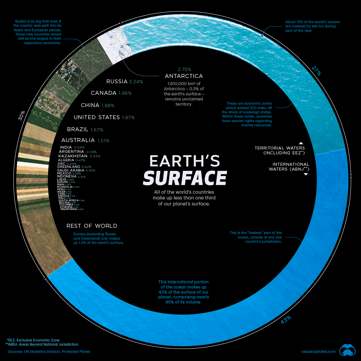
There are over 510 million square kilometers of area on the surface of Earth, but less than 30% of this is covered by land. The rest is water, in the form of vast oceans.
Today’s visualization uses data primarily from the United Nations Statistics Division (UNSD) to rank the world’s countries by their share of Earth’s surface.
Breakdown of Countries Share of Earth’s Surface
The largest countries by surface area are Russia (3.35%), Canada (1.96%), and China (1.88%).
Together they occupy roughly 7.2% of Earth’s surface. Russia is so big that even if we divided the country between its Asian and European sections, those new regions would still be the largest in their respective continents.

Antarctica, although not a country, covers the second largest amount of land overall at 2.75%. Meanwhile, the other nations that surpass the 1% mark for surface area include the United States (1.87%), Brazil (1.67%), and Australia (1.51%).
The remaining 195 countries and regions below 1%, combined, account for the other half of Earth’s land surface. Among the world’s smallest countries are the island nations of the Caribbean and the South Pacific Ocean. However, the tiniest of the tiny are Vatican City and Monaco, which combine for a total area of just 2.51 km².
The remaining 70% of Earth’s surface is water: 27% territorial waters and 43% international waters or areas beyond national jurisdiction.
Areas Beyond National Jurisdiction
In the past, nations adhered to the freedom-of-the-seas doctrine, a 17th century principle that limited jurisdiction over the oceans to a narrow area along a nation’s coastline. The rest of the seas did not belong to any nation and were free for countries to travel and exploit.
This situation lasted into the 20th century, but by mid-century there was an effort to extend national claims as competition for offshore resources became increasingly fierce and ocean pollution became an issue.
In 1982, the United Nations adopted the Law of the Sea Convention which extended international law over the extra-territorial waters. The convention established freedom-of-navigation rights and set territorial sea boundaries 12 miles (19 km) offshore with exclusive economic zones up to 200 miles (322 km) offshore, extending a country’s influence over maritime resources.
Does Size Matter?
The size of countries is the outcome of politics, economics, history, and geography. Put simply, borders can change over time.
In 1946, there were 76 independent countries in the world, and today there are 195. There are forces that push together or pull apart landscapes over time. While physical geography plays a role in the identity of nations, Sheikh Zayed bin Sultan Al Nahyan, the former ruler of UAE, a tiny Gulf nation, put it best:
“A country is not measured by the size of its area on the map. A country is truly measured by its heritage and culture.”
(This article first appeared in the Visual Capitalist)
{{ commodity.name }}
{{ post.title }}
{{ post.date }}


17 Comments
Sibangani
All is well and greeting.. Yes, The mines the companies must creates more jobs and includes more temporary jobs to stop people sufferings like my self I’m not working . Thank you God bless.
Herald Nicholas
You mentioned Russia and you never mentioned Africa. Your racist perspective cannot alter the geographical facts.
Guy
Africa is not a country… It’s a continent. Your desire to be right cannot make up for your ignorance.
[email protected]
I agree with u dats why I copy and paste ur comment
Dt
Africa is a continent made of many countries so your point is completely irrelevant. Get your facts straight before calling people racist.
Johnn
Ignorance is huge right here. Africa is a continent, not a country.
Anthony J Hartnell
Africa isn’t a country Harry!
Innit
Spectacularly dumb comment.
Kushal
Which is bigger: USA or China? Ive googled; it says USA, but here it is China
Guy
That would depend on whether you include any of their other territories or not. If you do, then it is China. If you don’t then it is the United States.
Denise
Very interesting. I magnified the picture so I could see all the countries on it and the percentages.
Alaaaan
You say that the international part of the ocean makes up 95% of ‘its’ volume. It seems like you mean the planets volume, but the volume of the oceans are a small fraction of the planets total volume.
Cool visualisation though and all the surface area info is great.
Steven
Greenland is not a country. It is a self-governed region, and is part of the Kingdom of Denmark.
Lovezbravo
Its my first time coming a cross such a mediocrity post, I wonder who was the editor ?
Imran khan
1947 Pakistan comes to world map. I respect and love to all countries and peoples but I hate to policies of USA and isreal. These two countries are doing to much Oppression on other countries for governing. They want to rule on all over the world. But every one knows that USA is very big Thief. Their economy is run by stealing oil from Arab countries. Shame on you USA.
Niti
Imran ~ the Holy Roman Empire owns all the corporations in the world and the Crown is their militia. They have held America under British Rule and operate as the U.S. corporation around the globe harming the people and the environment globally and making Americans look like thieves when truthfully Americans are operating under martial law and have been enslaved since the 1800’s thanks to Abraham Lincoln . Read the Paris Treaty for partial proof of this information. The rest is documented and occulted by the Holy See.
Matt
Which is bigger: USA or China? Ive googled; it says USA, but here it is China
GUY
September 27, 2021 at 8:43 pm
Africa is not a country… It’s a continent. Your desire to be right cannot make up for your ignorance