DroneDeploy Releases Improved Elevation and Volume Tools for Mining and Construction
Drone-based mapping is already bringing enormous insights and efficiency gains to a variety of industries. The ability to quickly get an overhead view of a jobsite is very useful for site planning and communication — but for many industries, particularly construction and mining, using drones to understand elevation data is even more valuable.
In February, we released our initial elevation and volume tools, which gave users a way to capture elevation data and measure stockpile volumes in a way that was faster and more cost-effective than ever before. With just one 15 minute flight, users can collect elevation data that would take hours — if not days — to collect with traditional ground-based surveying methods, and then instantly calculate volumes on completed maps.
That initial release was just the beginning. In the last four months, we’ve worked with our users to better understand how they use elevation data in their businesses, and we are excited to announce several new improvements to help make the elevation data in DroneDeploy even more powerful.
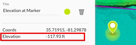
View the Elevation of a Point
Now you can immediately see the elevation of any point on your map when you drop a marker on a point. You can use these point elevations to measure the height of features, calculate slopes, and more. Note: elevation values are relative to point at which the drone took off. Learn more about viewing elevation data on your maps.
Calculate Volumes of Benches and Walled Piles
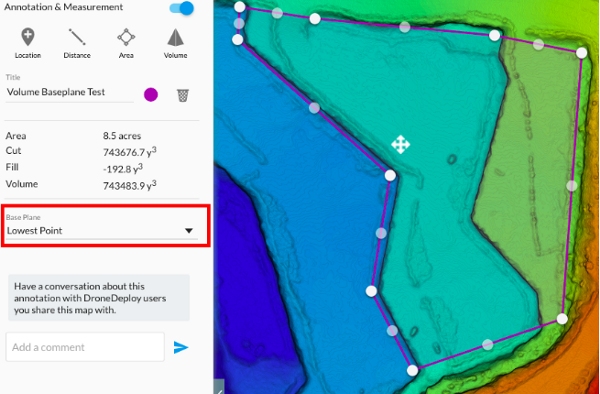
The original version of the volume tool released back in February allows users to outline a structure, e.g., a stockpile, and then instantly calculate the volume with a click of the button. Behind the scenes, DroneDeploy used the outline to define the “base” of the stockpile, and then compares the base to the surface of the pile to make the calculation.
The first version of the tool worked great for calculating stand-alone stockpiles on flat surfaces. In one case study, drone service provider Dallas VanZanten discusses how he used the DroneDeploy volume tool to calculate stockpile volumes at a granite processing plant to within 1% accuracy in a fraction of the time compared to traditional methods.
“Drones are safer, faster, and about half the cost as compared to traditional ground-based volumetrics.” — Dallas VanZanten
But what if you need to calculate and volume of a bench in a pit mine or walled stockpile where the base of the structure can’t be easily defined by drawing a perimeter on the ground? A small adjustment to our volume tool now allows you to use the lowest selected point to define the base of the volume want to calculate, making the volume calculation useful and accurate for a broader range of volume calculations.
Easily Export Elevation Data for Use in GIS Tools
Sometimes users want to combine elevation data from their maps with other data sets in third party software. For example, in a recent case study, major construction company Brasfield & Gorrie used a drone elevation map to compare actual earthwork completed on site against design plans. To do this kind of comparative work, or even to generate contour maps, users need to import elevation data from DroneDeploy into third party software.
Up until now, DroneDeploy users could only export elevation data as a point cloud, which is not compatible with many popular GIS tools and would need to be substantially manipulated to calculate elevation information and perform comparative analysis or generate contour maps. Today users can instead export raw elevation values as a GeoTiff (single band GeoTiff with elevation data encoded as 32bit floating point numbers at each pixel) that can easily be imported into ArcGIS, Civil 3D and other popular GIS tools.
Learn More

{{ commodity.name }}
{{ post.title }}
{{ post.date }}


Comments