South32 confirms Mozambique plant wind-down after profit beat
South32 last year took a $372 million impairment on the business.

VANCOUVER, BC / ACCESSWIRE / August 28, 2024 / Mako Mining Corp. (TSX-V:MKO)(OTCQX:MAKOF) ("Mako" or the "Company") is pleased to provide additional exploration results from the 2024 reverse circulation (RC) drill program in the Las Conchitas area, located immediately south of the Company's San Albino gold mine, and additional results from an ongoing regional reconnaissance program within Mako's 188 square kilometres land package.
The main objective of the RC drill program is to test for possible extensions of the high-grade mineralization trends beyond the limits of the Company's most recent mineral resource estimate ("MRE") at the San Albino Project (see press release of December 6th, 2023). The results reported in this release are from three principal veins: 1) Intermediate vein located within the Las Conchitas North ("LC-N") area, 2) El Limon vein and 3) Las Dolores vein, both situated in the southern portion of Las Conchitas LC-S (see Figure 1).
With the regional reconnaissance program, the Company is testing for new centres of high-grade mineralization, leveraging results of prior surface prospecting and locations of artisanal mining. The results are from channel and grab samples.
Drilling Highlights
Intermediate Vein
82.55 grams per tonne ("g/t") gold ("Au") and 76.9 g/t silver ("Ag") over 2.0m - (2.0m Estimated True Width ("ETW"))
19.31 g/t Au and 43.4 g/t Ag over 4.0m - (3.6m ETW)
Las Dolores Vein
16.83 g/t Au and 26.4 g/t Ag over 6.0m - (4.7m ETW)
14.70 g/t Au and 21.8 g/t Ag over 3.0m - (3.0m ETW)
El Limon Vein
12.27 g/t Au and 7.1 g/t Ag over 3.0m - (3.0m ETW)
Reconnaissance Highlights
El Golfo Area (located 3km south of San Albino)
62.20 g/t Au and 71.2 g/t Ag over 1.0m
86.80 g/t Au and 111.0 g/t Ag over 1.0m
21.65 g/t Au and 33.4 g/t Ag over 3.0m
Santa Rosa Area (located 5km east of San Albino)
358.60 g/t Au and 87.9 g/t Ag over 1.0m
141.6 g/t Au and 13.1 g/t Ag over 0.4m
Akiba Leisman, CEO of Mako states, "these drill results further indicate the potential to expand high grade mineralization in areas where we are currently mining. However, what is particularly exciting about these exploration data is the high-grade reconnaissance exploration program results we are receiving within our 188 square kilometer land package. We recorded 67 grab and channel samples grading over 10 g/t (and channel samples as high as 358 g/t over 1.0m) across individual structures that can be measured over two kilometres in strike length. The vast majority of these samples have been taken in areas that have never been drilled before, and preparation to begin drilling these regional targets has commenced."
Las Conchitas contains numerous mineralized structures over a 1,700m by 800m surface area, which has been subdivided into three primary areas: Las Conchitas North ("LC-N"), Las Conchitas Central ("LC-C") and Las Conchitas South ("LC-S"). Each of these areas are comprised of multiple subparallel, northeast-southwest striking and gently dipping mineralized veins.
Las Conchitas North (Intermediate Vein)
Drilling at the Intermediate zone, located within the LC-North area, is designed to test a previously identified high-grade mineralized zone outside the current MRE pit limits.
LC24-RC520 intersected 82.55 g/t Au and 76.9 g/t Ag over 2.0m (2.0m ETW), 46.5m below surface. This drill hole confirms structural continuity of the vein and demonstrates strike extensions of the high-grade mineralization intersected previously in diamond drill hole INT18-19 (see press release dated November 28th, 2018) which intersected 16.65 g/t Au and 12.1 g/t Ag over 1.20 m, located 14m northeast along strike.
Two drill holes LC24-RC513 and LC24-RC518 successfully tested the down dip extension of the same high-grade mineralization intersected by INT18-19, outside the current MRE. Drill hole LC24-RC513 intersected 19.31 g/t Au and 43.4 g/t Ag over 4.0m (3.6m ETW), 67m below surface and LC24-RC518 intersected 11.99 g/t Au and 17.0 g/t Ag over 3.0m (2.5m ETW), 60m below surface. These drill holes confirmed the down dip extension of the same mineralization for 60.2m and 31.0m, respectively.
Las Conchitas South (Las Dolores Vein)
The key objective of the 2024 drilling program at the Las Dolores area is to further test extensions of shallow, high-grade mineralized zones beyond the current MRE pit limits. Drill hole LC24-RC459 intersected 16.83 g/t Au and 26.4 g/t Ag over 6.0 m (4.7m ETW), 17.4m below surface and confirmed a 16m southwest strike extension of the mineralization intersected by LC24-RC458 of 30.85 g/t Au and 34.0 g/t Ag over 2.00m (1.8m ETW), 11.4m below surface (see press release dated July 29th, 2024).
Both drill holes mentioned above intersected the high-grade mineralized zones and confirm additional mineralization outside the current MRE and between two relatively small pits. The potential for one larger pit will be evaluated. (see Figure 1).
Drill hole LC24-RC521 intersected 14.70 g/t Au and 21.8 g/t Ag over 3.00m (3.0m ETW), 13.5m from surface and successfully confirmed a 13m down dip extension of the same high-grade mineralization intersected by drill hole LC24-RC458 mentioned above.
Las Conchitas South: (El Limon Vein)
Recent drilling at El Limon within the southern portion of Las Conchitas ("LC-S"), together with prior results drilled since the effective date of the MRE, supports the potential to expand the high-grade gold mineralization outside of the pit limits defined by the current MRE. Drill hole LC24-RC481 intersected 12.27 g/t Au and 7.1 g/t Ag over 3.0m (3.0m ETW), approximately 60m from surface and confirmed a 33m strike extension to the east of the high-grade mineralization intersected by diamond drill hole LC22-478 of 65.45 g/t Au and 41.7 g/t Ag over 1.80m, (see press release October 24th, 2022).
Regional Reconnaissance Exploration Program
The ongoing reconnaissance exploration program covers the Company's entire 188 square kilometer land package and includes geological mapping and sampling of exposed mineralized veins, local mine dumps, and, where safely accessible, underground workings. The main objective of the reconnaissance exploration program is to collect key structural data of mineralized veins, extend previously exposed high-grade gold mineralization and prioritize drilling targets, such as El Golfo, Potrerillos and La Reforma (see Figure 2) and to identify additional gold targets for follow-up exploration and drilling.
Reconnaissance results reported in this press release together with those previously released (See Press Releases dated: May 3rd, 2021, Aug 18th, 2021 and Mar 24th, 2022) are part of an ongoing regional exploration program that will soon include drilling at these and other prospective targets across our approximately 188 square kilometer land package. Results are reported for a total of 809 reconnaissance samples that were collected from underground workings, surface exposures and dumps, and they consist of both grab and channel samples. Of the 809 samples reported, 250 samples assayed over 1.0 g/t Au with 67 samples grading over 10 g/t Au (see Figure 2).
El Golfo Area
Historical mining and production within the area was centered primarily around the El Golfo Mine (covering approximately 2 square kilometers) in the early 1900's. Initial mapping and trench sampling by the Company confirmed the existence of high-grade gold mineralization that may be similar in both size and grade to that of the Las Conchitas and San Albino Gold Deposits, which are located approximately 1 kilometer and 3 kilometers, respectively, immediately to the north.
The recent reconnaissance exploration program conducted by the Company suggests the existence of additional mineralized zones proximal to the historical mining area. These new mineralized zones have not yet been tested by trenching or drilling.
Highlights of the reconnaissance sampling at the El Golfo area:
El Golfo West 62.20 g/t Au and 71.2 g/t Ag over 1.0m
El Golfo South 44.40 g/t Au and 64.9 g/t Ag over 1.0m and 18.70 g/t Au and 41.8 g/t Ag over 3.0m
Tivo 86.80 g/t Au and 111.0 g/t Ag over 1.0m and 21.65 g/t Au and 33.4 g/t Ag over 3.0 m
Los Centenos 26.98 g/t Au and 32.7 g/t Ag over 2.5m and 37.80 g/t Au and 30.8 g/t Ag over 1.0m
New Prospects
Reconnaissance mapping and sampling has identified several new prospects with similar characteristics to San Albino and Las Conchitas (see attached maps). The most extensive prospect, Santa Rosa, exposed recently by local, small-scale miners using manual mining methods, and situated on both the El Jicaro and San Albino-Murra concessions, appears to be developed on the same structure with a strike extent of at least 2,300m. The prospects are centered around quartz veins similar to those at San Albino and Las Conchitas with occasional visible gold, galena and arsenopyrite. The highlights of channel sampling of the vein are as follows:
358.60 g/t Au and 87.9 g/t Ag over 1.0m
141.6 g/t Au and 13.1 g/t Ag over 0.4m
Additional new prospects identified in the reconnaissance mapping include La Virgen, El Cortez, Mina Estrella, Fortuna NE and La Reforma North (see figure 2). Follow-up sampling and mapping is being conducted in these areas.
Table - Assay Results Reported in This Press Release
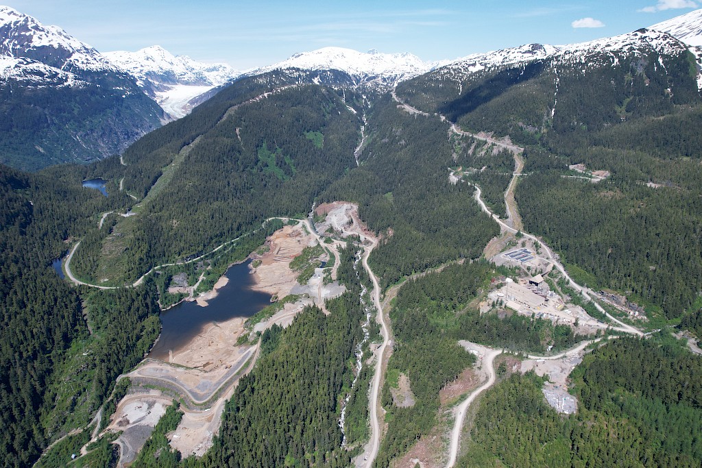
Note: The mineralized intervals shown above utilize a 1.0 g/t gold cut-off grade with not more than 1.0 m of internal dilution. *Widths are reported as drill hole lengths. True width is estimated to be between 70% and 100% of the downhole width. In addition to the drill holes presented in the table above, the following drill holes returned only anomalous values: LC24-RC484, LC24-RC486, LC24-RC525 and LC24-RC529. In addition to the drill holes presented in the table above, the following drill holes returned no significant values: LC24-RC514, LC24-RC542, LC24-RC523, LC24-RC524 and LC24-RC528.Figure 1. Drill Hole Plan Las Conchitas
Figure 2. Reconnaissance Surface Sampling
Sampling, Assaying, QA/QC and Data Verification
All reverse circulation (RC) holes were drilled dry i.e above the water table and no water or other fluids were injected into the hole. RC drill samples were collected every 1 meter using a center-return hammer and samples were obtained from a Gilson chip splitter which is cleaned using compressed air after each sample. Samples were bagged and labeled at the drill site under a geologist's supervision and are logged on site by a geologist who visually selects potential mineralized intervals for fire assay. The mineralized interval(s) including 3-5 samples above and below, the selected interval are continuously sampled and shipped to the Bureau Veritas Lab (BV) in Managua, respecting the best chain of custody practices. Pulps are sent by Bureau Veritas to their laboratory in Vancouver under their chain of custody for analysis. Gold was analyzed by standard fire assay fusion, 30 gr aliquot, AAS finish. Samples returning over 10.0 g/t gold are analyzed utilizing standard Fire Assay-Gravimetric method. The Company follows industry standards in its QA&QC procedures. Control samples consisting of duplicates, standards and blanks were inserted into the sample stream at a minimum ratio of 1 control sample per every 10 samples. Analytical results of control samples confirmed reliability of the assay data.
Surface samples consist of channel samples, trench samples, grab and float samples. Channel samples are continuous chip samples collected perpendicular to the structures in order to represent the approximate true width of the veins. Dump samples are approximately 2 kilogram samples collected from the surface of dumps developed from previous mining activities. Care was taken to collect samples that are representative of the material on a specific dump. Grab and float samples are taken to identify anomalous areas for follow-up sampling.
Samples were kept in a secured logging and storage facility until such time that they were delivered to the Managua facilities of Bureau Veritas and pulps were sent to the Bureau Veritas laboratory in Vancouver for analysis. Gold was analyzed by standard fire assay fusion, 30-gram aliquot, AAS finish. Samples returning over 10.0 g/t gold are analyzed utilizing standard Fire Assay-Gravimetric method.
Qualified Person
Brian Ray, M.Sc., P.Geo, a geologist and qualified person (as defined under NI 43-101) has read and approved the technical information contained in this press release. Mr. Ray is a consultant to the Company.
On behalf of the Board,
Akiba Leisman
Chief Executive Officer
About Mako
Mako Mining Corp. is a publicly listed gold mining, development and exploration company. The Company operates the high-grade San Albino gold mine in Nueva Segovia, Nicaragua, which ranks as one of the highest-grade open pit gold mines globally. Mako's primary objective is to operate San Albino profitably and fund exploration of prospective targets on its district-scale land package.
For further information: Mako Mining Corp., Akiba Leisman, Chief Executive Officer, E-mail: [email protected], phone: (917) 558-5289 or visit our website at www.makominingcorp.com and SEDARPLUS www.sedarplus.ca.
Forward-Looking Information: Some of the statements contained herein may be considered "forward-looking information" within the meaning of applicable securities laws. Forward-looking information can be identified by words such as, without limitation, "estimate", "project", "believe", "anticipate", "intend", "expect", "plan", "predict", "may" or "should" or variations thereon or comparable terminology. The forward-looking information contained herein reflects the Company's current beliefs and expectations, based on management's reasonable assumptions, and includes, without limitation, that the Company high-grade production will generate significant cash flows for the foreseeable future. Mako's primary objective to operate San Albino profitably and fund exploration of prospective targets on its district-scale land package. Such forward-looking information is subject to a variety of risks and uncertainties which could cause actual events or results to differ materially from those reflected in the forward-looking information, including, without limitation, changes in the Company's exploration and development plans and growth parameters and its ability to fund its growth to reach its expected new production numbers; unanticipated costs; the October 24 measures having impacts on business operations not current expected, or new sanctions being imposed by the U.S. Treasury Department or other government entity in Nicaragua in the future; and other risks and uncertainties as disclosed in the Company's public disclosure filings on SEDAR at www.sedarplus.ca. Such information contained herein represents management's best judgment as of the date hereof, based on information currently available. Mako does not undertake to update any forward-looking information, except in accordance with applicable securities laws.
Neither the TSX Venture Exchange nor its Regulation Services Provider (as that term is defined in the policies of the TSX Venture Exchange) accepts responsibility for the adequacy or accuracy of this release.
SOURCE: Mako Mining Corp.
View the original press release on accesswire.com


The new Mining Power Rankings are live. Vote for the sector’s leaders in each of the Large-, Small-, and Micro-Cap leagues.