Drone mapping is growing at a rapid rate in almost every country in the world. Unfortunately, incidents with drones are also growing at the same time. Just like any other aircraft, drones not only need to be flown in a safe manner but flight operations need to fully integrated within a countries civil and/or military regulatory aviation environment. Authorities such as the British Civil Aviation Authority (CAA), the European Aviation Safety Authority (EASA) or the Federal Aviation Administration (FAA) of the United States provide rules and regulations for a safe and legal operation with the aim of minimising dangers to people, property and other aircraft.
In this case study we look at measures and counter measures that QuestUAV have employed to enhance safety when operating in urban environments through the example of our Korean flight team from Hojung Solutions. The team operates QuestUAV drones for a variety of urban applications while they are obliged to follow the strict rules of the South Korean aviation authority. Their advanced in-country training from QuestUAV has allowed new standards to be set for the use of drones for civil applications in South Korea.
Hojung mission
Applications and Safety in Urban Areas
Urban areas have various faces and UAVs can be used for a wide range of applications, starting from mapping urban zoning and expansion through 3D modelling of cities and cadastral surveys to inspecting infrastructure elements such as roads, pipelines and buildings. This study focuses on the experiences of the team from Hojung Solutions in South Korea, presented as an excellent example of the challenges of operating fixed wing UAV in built up and congested areas. Bearing in mind that South Korean safety requirements to UAVs are similar to the UK, QuestUAV drones are setting the standard for fixed wing drones in the country. Most importantly: the Hojung team is well-trained by QuestUAV as manufacturer and 100-percent professional in following safety standards and procedures at any mission.
Primarily the issue of maintaining Visual Line Of Sight (VLOS) whilst still retaining full control of the UAV were the highest concerns. However other issues such as higher rate of local interference, loss of visibility from high buildings, poor selection of emergency landing areas, higher risks of unexpected interferences (including unexpected public interactions and unexpected interactions as and when moving on highways) were of concern.
QuestUAV’s first level of consultation took us to examination of the aircraft, its safety functions and how it could fit governmental regulatory requirements. Parachute, manual and auto landings, motor failure and energy dissipation on impact, risk of unlawful interference and poor GPS signal, were all aspects that were considered and blended into the software and hardware setup for the UAV fleet to be used in South Korea.
The second level of consultation required verification of the QuestUAV system in South Korea and a detailed investigation into training sites that could be used where challenges were realistic but real risks were low. A site on the outskirts of a newly developed city was chosen that provided all the elements density and high structure to the East and North, whilst having open and safe spaces for operations to the South and West.
The on-site flight teams needed to be skilled in a larger range of disciplines. Third level of QuestUAV’s consultation was therefore the standard manufacturer training in South Korea. The lead pilot had also received further QuestUAV training in UK.
The day to day process of briefing and equipment preparation needed to become an artform that raised standards in every area. One example is to use radio communication disciplines to allow remote observers to participate in an effective safety strategy that covered visibility in blind spots and better forecasting of events that might become risks.
Urban Mapping Examples
Our South Korean team from Hojung Solutions has been successfully flying in urban areas since autumn 2015. Their list of achievements is incredible. Some of the most impressive examples are already published on our website123.
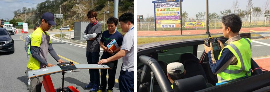
Hojung Road Survey 300km
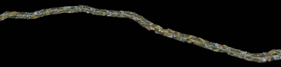
The 300km road survey in South Korea was probably the team’s most difficult challenge. In order to keep Visual Line Of Sight (VLOS) the flight team had to follow their Q-200 Surveyor drone on the ground in an open car and never be further away than 500m. The team took advantage of the QuestUAV safety features like dual system, ERP and orbiting options greatly supporting the mobile operations. A section of the road survey is shown above. Other great achievements are the survey of Madang City in Papua New Guinea as basis to design a municipal storm drainage system and several high accuracy topographic surveys for the South Korean governmental survey agency. The figure below shows several examples of urban features and the general QuestUAV image quality.
QuestUAV Safety Features in Detail
A well trained crew is of utmost importance for a safe flight mission. QuestUAV places high priority on training clients on a safe UAV operation, which involves more than just practicing takeoffs and landings. The whole workflow has to be practiced over and over again, starting from mission planning, base checks and crew briefing through to operating a UAV in different scenarios and a safe UAV recovery after landing. QuestUAV has long-term experience in operating UAVs in different conditions and for various applications. Proven workflows are one of our outstanding safety strengths.
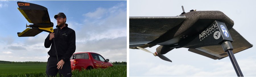
DATAhawk Airdock
QuestUAV drones involve great safety features, starting with the material characteristics of the UAV itself. Our drones are light but also very robust, meaning that they can absorb a high amount of energy during any impact. Depending on the system QuestUAV drones are launched via airdock (Q-100 DATAhawk) or launch line (Q-200 systems), which avoids direct contact between launch person and drone. QuestUAV drones are generally flown in automatic mode (including auto-takeoffs and auto-landings), but in case of an emergency the pilot can always take control and fly the UAV in assisted or manual mode. Our drones are dual-systems, meaning that either the pilot can take control with the remote control or the commander can operate the aircraft from the flight laptop. QuestUAV drones have an outstanding redundancy, including commercial avionics, fail-safe, geo-fencing, return-to-home options, battery warnings, ERP (Emergency Rally Point) and orbiting options.
Summary
UAVs must always be flown in a safe manner both with respect to other aircraft in the air and also to people and properties on the ground, especially when operating in urban areas. QuestUAV drones come with great safety features to reduce mission risk and provide high quality data at the same time. Professional manufacturer training on flight operation, safety and proven workflows is the outstanding safety feature of QuestUAV.