Eureka modelling software from 3D visualisation technology developer Maptek is being applied to the construction of a multi-billion transport infrastructure project in Qatar.
The infrastructure project, managed by Qatar Rail, will create a rapid transit network consisting of light rail, the metro system and high speed trains between Qatar and Saudi Arabia.
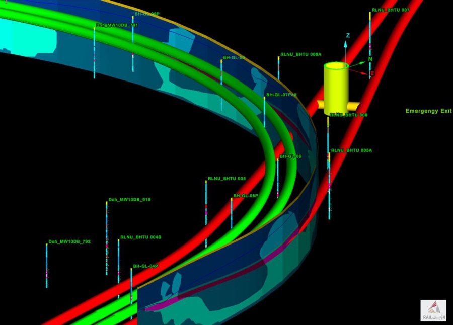
Qatar Rail uses Eureka to view, analyse and model regional geological and GIS data.
‘Eureka modelling and analysis tools allow us to investigate critical aspects in relation to the conditions underground and structures to be erected,’ said Marin Griguta, Director Civil Works, QIRP Department at Qatar Rail.
Within Eureka data is amassed into a single, spatially coordinated database for creating detailed 3D geological and geotechnical structures – key for the planning of viable construction routes.
Flexibility of data export to GIS and CAD programs was a required software feature.
‘We bring in CAD data, GIS (.shp) files, referenced and unreferenced images, borehole logs, downhole geophysics and recent seismic data to model within Eureka,’ added Griguta.
‘Visualisation of the underground structures and geotechnical conditions helps guide our decisions as to how to proceed with design and construction,’ he added. ‘Eureka supports this aspect of the project in a way that traditional 2D tools could never deliver.’
‘Maptek technology is designed to meet the rigorous demands of industry, handling massive datasets and enabling sophisticated 3D modelling. The tools are therefore ideal for use in large scale engineering projects such as the transport network being undertaken by Qatar Rail,’ said Gary Buchanan, Operations Manager, Maptek Europe.
As with all customer sites, feedback from this project will be used by the Maptek development team to improve future Eureka releases.
About Maptek
Founded 35 years ago, Maptek™ is a leading provider of innovative software, hardware and services for global mining. Maptek solutions are used at more than 1800 sites in 75 countries, with applications across the mining cycle. Maptek develops industry-leading software Vulcan™, Eureka™, Evolution and BlastLogic™ for mine evaluation, planning, design, scheduling, operation and rehabilitation. I-Site™ is integrated hardware and software for 3D laser scanning, surveying and imaging. The spatial data collected can be used for geotechnical analysis, stockpile measurement, design conformance and movement tracking supported by software systems I-Site Studio, Drive, PerfectDig™ and Sentry.
About Qatar Rail
Qatar is a growing country, and to accommodate this growth, a new, sustainable, and efficient way of getting both people and freight around the country was needed. Established by Emiri decree in 2011, Qatar Rail was given the mandate to design and develop the country’s rail network, and after the rail projects are completed, manage, operate, and maintain them.