How Auracle’s MUD® Model Revolutionizes Global Tailings Dam Monitoring
Auracle Geospatial announces its Mapped Underworld Dimension (MUD®) model, an advanced satellite-based monitoring tool that penetrates and models the earth’s surface, near subsurface and underwater in 3D. MUD® is a breakthrough technological tool that provides subsurface and underwater monitoring to alert tailings facility operators of structural problems and hidden risks before they become threats to facilities, the environment and human life.
Brief Overview
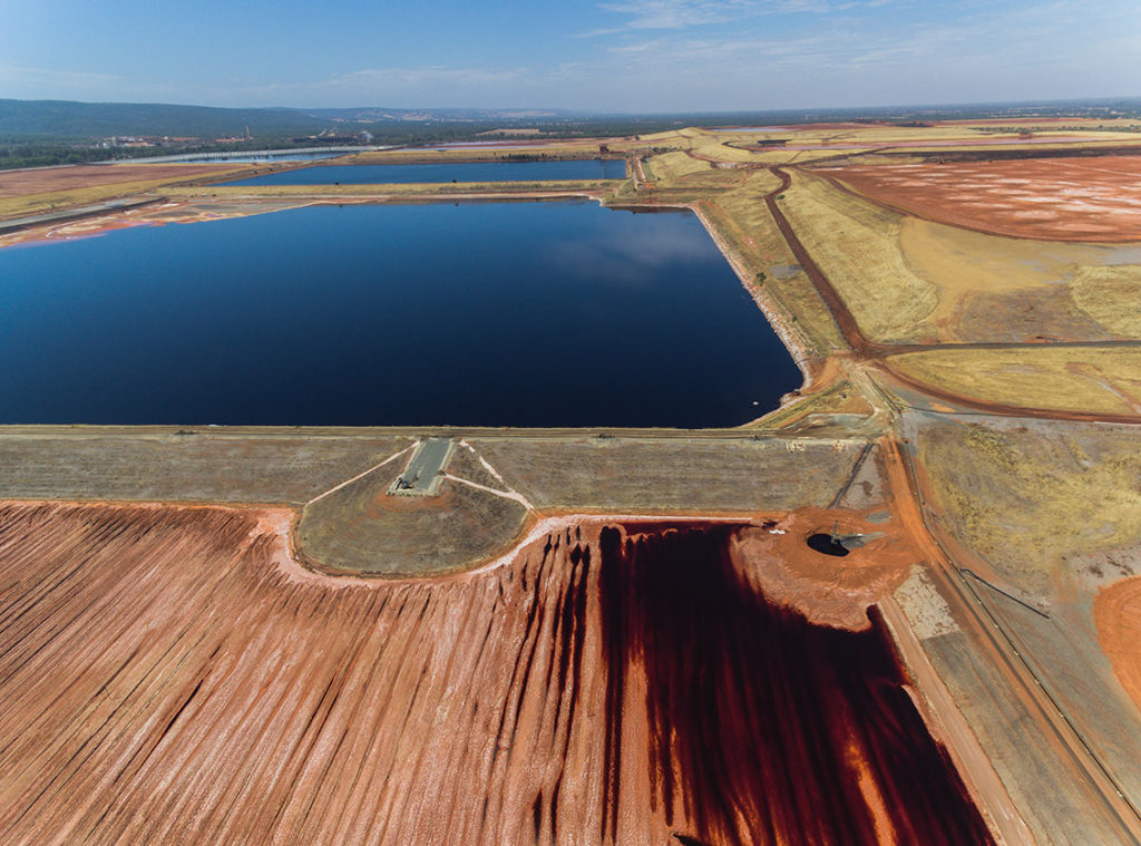
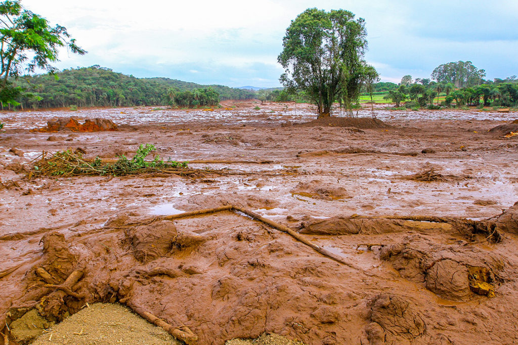
Current TSFs monitoring systems do not provide early warning for operators. Tailings dam failures are predicted to increase and at an accelerated rate. With the world’s estimated 29,000-35,000 existing active, inactive and abandoned TSFs containing approximately 534 billion cubic meters of material, new technological advances, using satellite data, must be adopted. Auracle believes in order to help prevent the predicted failures, we must monitor the subsurface and provide operators with a predictive tool that allows operators to visualize real but unseen geohazards. MUD® system is a fail-safe TSF monitoring and management system that interacts with critical subsurface and underwater environments.
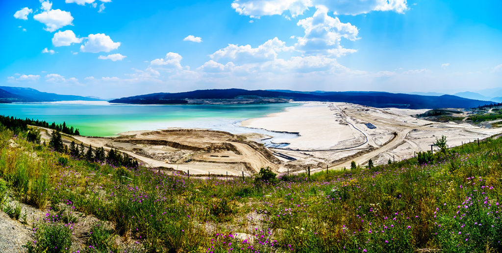
To correct the persistent failure of tailings dam facilities, a monitoring system must allow sufficient reflex time for intervention and must monitor where failures are born, typically within the dam, under the surface and on the “wet” side. When outer surface change is detected, failure is imminent and early warning opportunities are lost. Auracle provides a disruptive tool that advances satellite radar to monitor surface, subsurface and underwater displacement, where tailings dam failure is at greatest risk. The MUD® system can “see” and measure subsurface and underwater change and patterns of change in 3D.
How MUD® Advances Traditional Monitoring
With a positionally accurate fused radar technology as its base, the AI component of MUD® automatically identifies change using subsequent satellite data collected over time to provide a reliable 4D “state of change” analysis. This accurately locates and describes the amount, type, rate and direction of change within a tailings facility. This revolutionary 3D earth modeling methodology penetrates foliage, ground and water to visualize the unseen and forms an ideal digital twin. The MUD® model works at, near and underneath the earth’s surface to “see through” water, deep vegetation, ice, snow, rocks and soil to identify structures, lithologies, geo-hazards, saturation levels and changes. The MUD® system replaces point or grid-based surveys and precisely detects movement or deformation under the Earth’s surface, resulting in actual not derived ground information. This means that the small 3D patterns that can precede major change or failure can be revealed. Because the MUD® system eliminates noise and distortion, it provides complete coverage, rather than the statistical evaluation and simple model of the apparent surface provided by other surface monitoring systems.
“I am very impressed by the Auracle technology and its potential application to the vast tracts of the planet that are covered by sand, glacial till or vegetation” said Richard Williams, P. Geo and CEO of Cornish Metals Inc.
What makes MUD® technology stand out?
Tailings dams are one of the most critical liabilities associated with the mining industry. MUD® drastically reduces this liability with its unprecedented capacity to monitor the unseen hazards that exist within the subsurface and on the “wet” side of the dam. This monitoring ability is completely remote, provides advanced warning, requires no equipment or boots on the ground, is cost effective and has a zero-carbon footprint. MUD® has the capacity to yield a safer and stronger mine for the workers, the public and the environment. In addition, MUD® provides operators with the ability to reduce overall operating costs in four cost centers: monitoring, maintenance, accident and remediation cost.
The benefit of employing the MUD® system across the entire network of tailings facilities include but are not limited to:
- A reliable monitoring system that can actually provide early warning and early detection of surface, subsurface and underwater change
- A system that can produce a complete digital twin of each facility
- A reliable monitoring system with the capacity to detect change, approximate rates of change, define and detect patterns of change, all with a dramatic increase in ground spatial resolution
- A system that facilitates the transfer of information during changes in ownership and engineers of record
- A system that visualizes subsurface water flow direction unseen by the eye or any other system
- A system that can be tailored for frequency on each location, based on information not hypothesis
- A system that cuts cost and increases intelligence
Our methodology can be performed throughout the year, without permits, or public scrutiny. Auracle’s system uses a multi-disciplinary, collaborative approach that exploits remote sensing data at a variety of scales, from regional scale to project scale. This continuous monitoring capability can provide decision makers the most up-to-date information of the target area or region during planning, throughout full-scale operations, or to visualize changes that occur over time, well in advance of catastrophic failures.
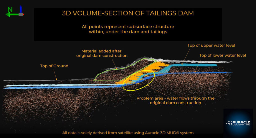
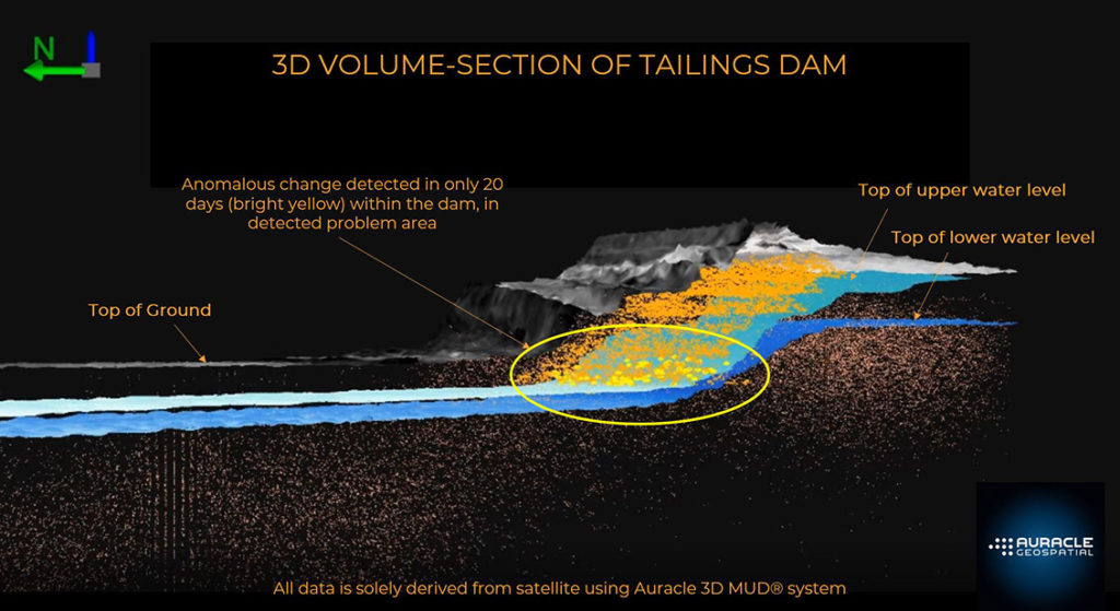
Case Example
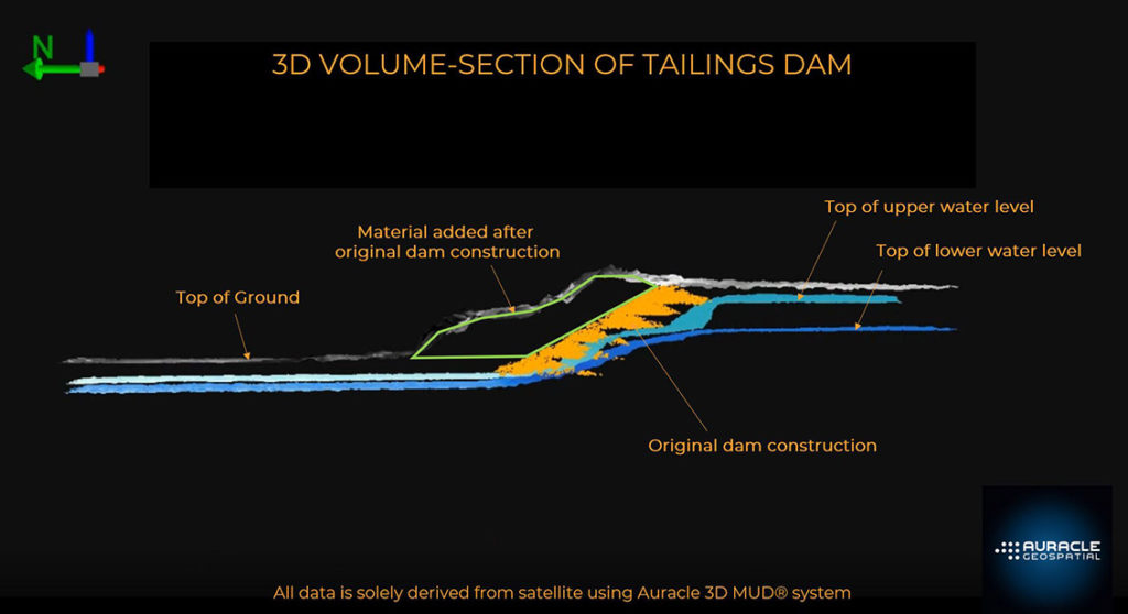
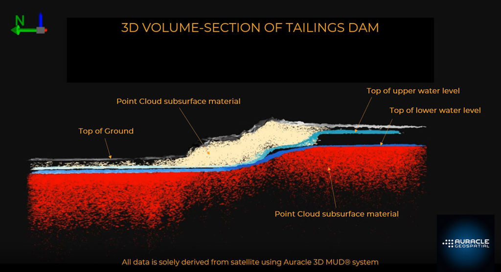
MUD® data are presented as 3D point clouds which can be analyzed for their characteristics and classified according to specific needs. Each point within the cloud can be queried for its exact location and change over time. Typically presented as a volume of data, these point clouds can be sliced to reveal sections within the solid earth to aid in the understanding and definition of composition. These slices are direct representational tomographic cross sections of actual signal data.
Embracing Disruptive Tools to Prepare and Reduce Environmental Impact
The MUD® system is a fully-developed proprietary application utilized by Auracle. There are no developmental requirements needed at this time in order to acquire, detect and produce accurate and reliable intelligence for TSFs monitoring across your network. The system monitors surface, subsurface and underwater change in 3D well in advance of events that threaten infrastructure. MUD® operates day or night, through all weather and creates no human or environmental impact.
Auracle’s vision is to provide a monitoring service which delivers the necessary reflex time needed to prevent catastrophic tailings dam failures. This can only be accomplished by utilizing Auracle’s technological advancements that detect and capture subsurface and underwater information. Maintaining the status quo and not embracing new, yet disruptive technology can only yield the same results. When the MUD® system is employed, operators can be fully informed and enabled to be proactive in mitigating the threat.
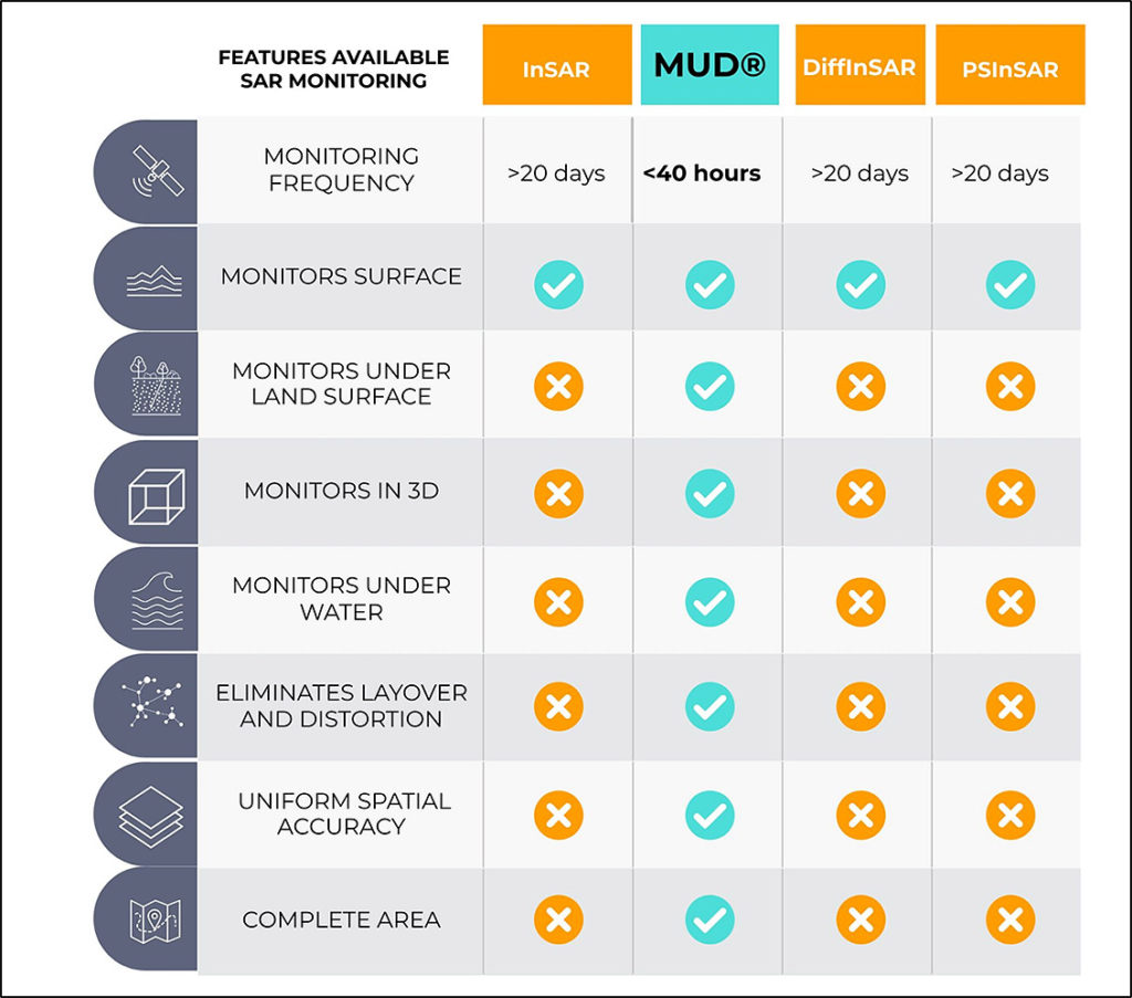
Monitoring Comparison Table
Contact Us Today
For more information on Auracle’s MUD® system, tailings storage facilities monitoring services and to learn more about how we can help you, visit www.auracleremotesensing.com or call 250-738-0459.
Comments