ZEB1 Laser Scanner Put Through its Paces at World’s Deepest Gold Mine
Nottingham, UK, 02 January 2014 – ZEB1 the world’s first truly mobile, hand held, rapid laser mapping system has been put through a rigorous testing process at the world’s deepest and most substantial gold mine. Owned and operated by Anglogold Ashanti the Mponeng Mine in South Africa is over 2 kilometres below sea level. The ZEB1 was demonstrated in an ‘up dip stope panel’ and the resulting 3D model was proven to conform to existing plans of the mine workings.
“Before commissioning any new equipment we always undertake rigorous testing as the environment in which we operate is so extreme; with virgin rock temperatures around 60 degrees Centigrade and working temperatures between 30 and 35 degrees.” commented Michael Harcombe, Senior Mine Surveyor at Anglogold Ashanti’s Mponeng Mine. “At these ambient levels, sensitive equipment, such as laser scanners, often just do not work!”
“The results of the ZEB1 test were much better than we could possibly have expected,” he continued. “The model generated from the ZEB1 scanning was placed in the mine’s plans for a comparison with the current excavation and found to conform to the outline of the workings. We were hoping to compare the results with our existing laser scanning set up however the test area was simply too small for traditional laser scanners another significant advantage for the ZEB1.”
The Mponeng Mine is located between the towns of Carletonville and Fochville on the border between Gauteng and the North West Province, southwest of Johannesburg. The operation, the world‘s deepest mine, extracts the Ventersdorp Contact Reef (VCR) at depths between 2,400 metres and 3,900 metres through sequential-grid mining producing more than 500,000 ounces of gold a year.
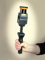
Developed by CSIRO and commercialised by UK based 3D Laser Mapping, ZEB1 uses robotic technology called Simultaneous Localisation and Mapping (SLAM). The ZEB1 system includes a lightweight laser scanner mounted on a simple spring mechanism, which continuously scans as the operator walks through the environment. As the scanner loosely oscillates about a spring it produces a rotation that converts 2D laser measurements into 3D fields of view. Its ability to self-localise makes ZEB1 ideally suited for use indoors, underground and in other covered environments where traditional solutions that utilise GPS don’t function well.
Anglogold Ashanti already operate a traditional terrestrial laser scanner at the Mponeng Mine. The RIEGL VZ-400, purchased from 3D Laser Mapping, is used to monitor workings for signs of deformation; a common phenomenon as rocks at such depths can be under enormous pressure. Anglogold Ashanti also use the VZ-400 to determine off-line and grade mining, eradicating the need for later redevelopment and therefore reworking of areas already mined.

{{ commodity.name }}
{{ post.title }}
{{ post.date }}


Comments